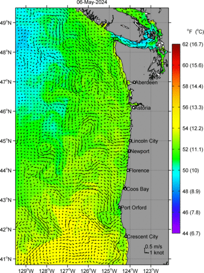
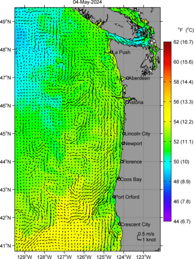
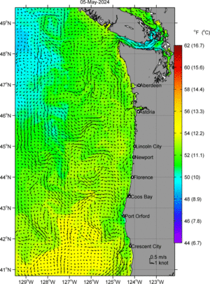
Sea Surface Currents (arrows) & Sea Surface Temperature (color) Nowcast/Forecast Fields
The experimental nowcast and forecast fields displayed to the right are produced by a computer model of the Oregon coastal ocean circulation. These forecasts are updated daily at approximately 12:15 pm. Click here to view enlarged versions of the thumbnail images.
An important part of the input to the model is a 5-day record of winds over the Oregon coast. This record is derived from an operational weather forecast model, and covers the past two days and the forecast for the coming three days. Each day, the model takes this record and its previous estimate of the ocean state from two days before, and combines it with a mathematical representation of the physical principles for fluid motion. The result is, each day, a 3-day nowcast and forecast record.
To improve accuracy of forecasts, the model ocean estimate is optimally combined with recent observations. This melding of the model and the data is called data assimilation. In our case, initial conditions for the forecasts are constrained by assimilation of surface currents measured remotely by high-frequency (HF) radars installed along the coast and satellite sea surface temperatures (in particular, using the data from the geostationary GOES satellite).
User comments on the utility and accuracy of the research model products available on this website are encouraged, and may be submitted here.
Drs. Lana Erofeeva, Peng Yu, and Alexander Kurapov at COAS, OSU have contributed to the development of this operational coastal ocean model, which is based on the Regional Ocean Modeling System. Currents, temperature, salinity, sea surface height, and other dynamic information are obtained at 3-km resolution. The wind and surface heat flux forcing are obtained from the NOAA/NCEP mesoscale atmospheric NAM operational forecast model. The model also utilizes information about average seasonal changes in the surrounding ocean, derived from the 4-year output of the 9-km resolution Naval Research Laboratory (NRL) NCOM-CCS regional model (J. Kindle, I. Shulman, and S. de Rada). The basic model configuration is based on related research described by Springer et al. (2009), Koch et al. (2010) and Kurapov et al. (2011). Details of the variational data assimilation method utilized can be found in (Kurapov et al., 2011).
This nowcast and forecast information is provided by the Oregon Coastal Ocean Simulator Group.
This work has been supported by the Cooperative Institute for Ocean Satellite Studies (CIOSS).
Disclaimer: The coastal ocean forecasts displayed here are an experimental product intended for research use only. In no event will OSU or any of its employees be liable for any direct, indirect, incidental, consequential, special or exemplary damages or lost profit resulting from any use or misuse of these research model forecasts.
Kurapov, A. L., D. Foley, P. T. Strub, G. D. Egbert, and J. S. Allen, 2011: Variational assimilation of satellite observations in a coastal ocean model off Oregon, J. Geophys. Res., submitted, pdf.
Koch, A. O., A. L. Kurapov, and J. S. Allen, 2010: Near-surface dynamics of a separated jet in the coastal tranzition zone off Oregon, J. Geophys. Res., 115, C08020, doi:10.1029/2009JC005704.
Springer, S. R., R. M. Samelson, J. S. Allen, G. D. Egbert, A. L. Kurapov, R. N. Miller, and J. C. Kindle, 2009: A nested grid model of the Oregon coastal transition zone: simulations and comparisons with observations during the 2001 upwelling season, J. Geophys. Res., 114, C02010, doi:10.029/2008JC004863, pdf.
Today: Nowcast
24 hr Forecast
48 hr Forecast